Saturday, June 16, 2012

YELLOWSTONE PART VIII


We have been really enjoying our campsite here at Canyon Campground. It’s surrounded by lodge pines, is private and has a very nice picnic area with fire pit. We have had a lot of campfires and even cooked s’mores a couple of nights. For the uninitiated, s’mores are 2 graham crackers with a half of a chocolate bar and a toasted melted marshmallow sandwiched between them.  Yum..
Camping at Canyon Campground in Yellwostone
Notice the snow on the right side!

The weather has been staying in the high 50s during the day and low to mid 30s at night so we are still in need of our heater. Thankfully, it is working fine.

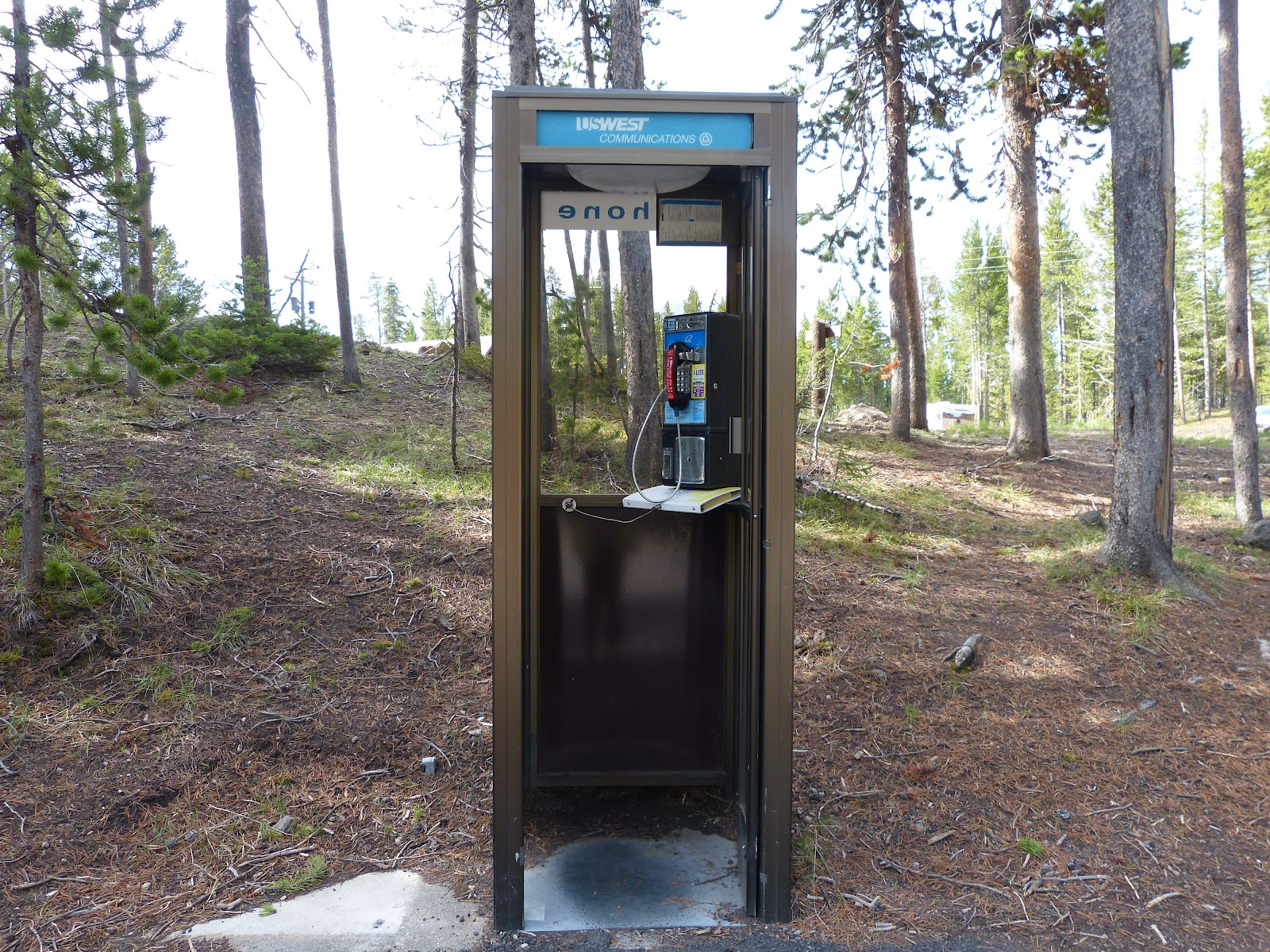
Does anyone remember using one of these? Did you ever see one out in the middle of the woods? Haven’t seen one in so long, but we found it out in the middle of nowhere and the only thing you can dial on it is 911 to the Park Ranger! Guess that’s good because our cell phones don’t work very well here.

               
Today, Friday the 15th, it is still rather cool, but Tim did his early morning run again to see if he could repeat the wildlife extravaganza he had yesterday, but it was not to be. No wildlife at all while he sat patiently and waited in the car. Not me… I stayed bundled up in bed until the RV warmed up to the cozy 68 we set it for in the morning. Much better than the 55 setting during the night.

We decided to do a driving tour today with only a few short walks along the way. We traveled from Canyon Village to Norris and took the detour road off of the Grand Loop to view the Virginia Cascades.   We also stopped at Ice Lake for a 1 mile walk. At the trails’ end, we were inundated with mosquitoes and beat a quick retreat to the car.
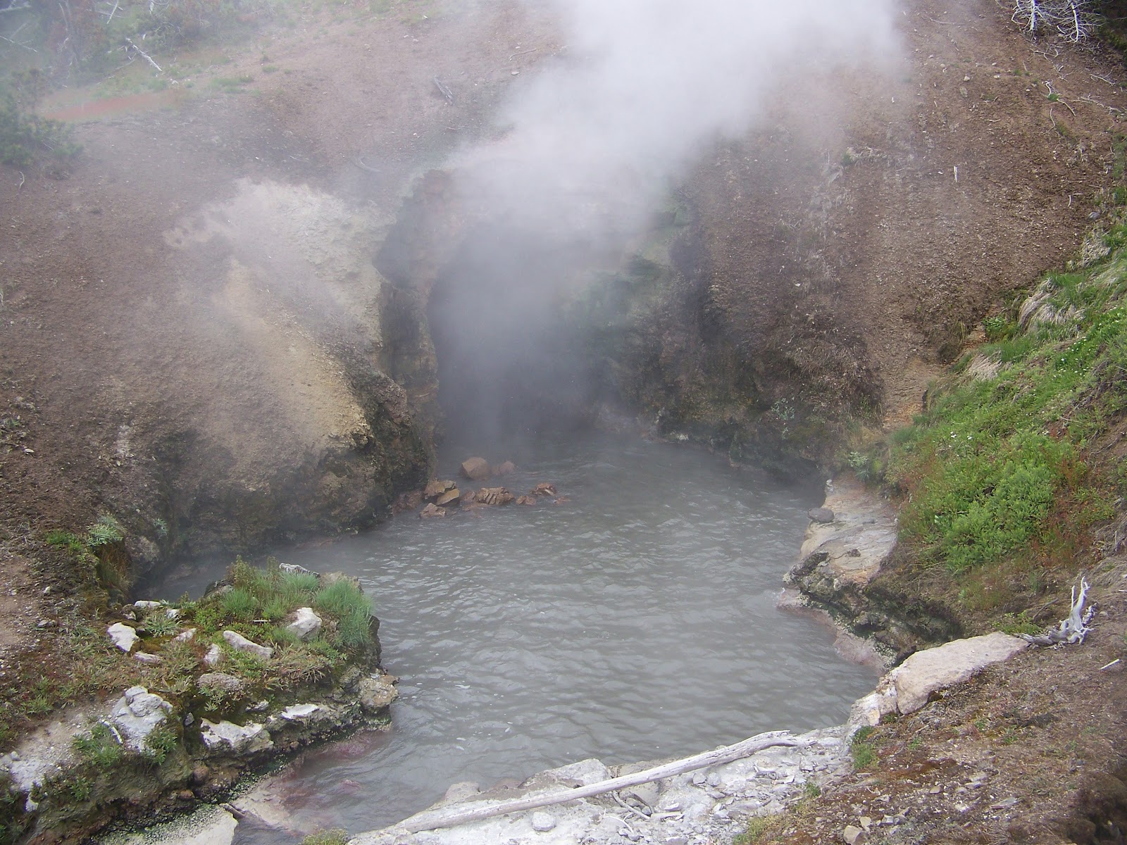
When we arrived at the Norris Geyser Basin, it was about 11am and it was already very crowded. This Basin is one of the hottest hydrothermal areas in Yellowstone. The literature tells us that it has many hot springs and fumaroles with temperatures above the boiling point (200 degrees F). They say that it is hard to imagine a setting more volatile than Norris as it is part of one of the world’s largest active volcanoes. Basically, the hydrothermal areas are fueled by magma which is partially molten rock. The magma heats the water percolating down from the surface and when superheated rises back to the surface. Depending on the makeup of a particular area, it will cause a geyser, a hot spring, a fumarole (steam vent) or a mud spot.  The different colors are caused by either sulphur (yellow), iron (dark brown, rust or red), chlorophyll (emerald green), or algae (dark, blackish-green) and when the sun hits them just right, they are brilliant.   

We walked the boardwalks and were indeed impressed by the beauty of the Geyser Basin beneath the Gallatin Mountain Range.
Geyser Field
A Fumarole
Geyser Field in front of Gallatin Mountain Range

We journeyed down the Grand Loop which follows the rim of the caldera (the upper edge of the original volcano in Yellowstone) towards Madison taking in the Gibbons River, Meadows and then the Falls. We passed through Madison Junction and took the Firehole Drive to see the Firehole Falls and River.  The sheer force of the water going through these canyons is impressive. At one time, this was all volcano and the canyons were formed by molten lava.
Firehole Falls
  Once the rains started, we retraced our route and found the sun again on Gibbons Meadows where Tim tried his luck at fly fishing again.

Gibbons Meadows
There were actually quite a few fishermen out in the stream and rivers today and we didn’t see anyone catching anything. I think these guys just use this as an excuse to spend time alone. What do you think?  That’s okay..I brought the computer with me just in case and had a chance to sit and download my pictures while Tim had some quiet time. I guess it works both ways.

Friday, June 15, 2012

YELLOWSTONE PART VII

The rain stopped early this morning, Thursday the 14th, so Tim went out early down to Hayden Valley to see if he could catch some wildlife before all the traffic started on the Grand Loop Road. He was rewarded with Pronged Horned Deer and another Grizzly Bear that walked right across the road to a copse of trees where the Deer were. He chased them out of the trees and they went running across the meadow. We would have been running too!


Pronged Horn Deer Running from Grizzly Bear

After breakfast, we drove up towards Tower Falls. Along the way, we stopped frequently to take pictures of the Washburn and the Absoroka Mountain ranges. We drove up the Chittendon road to the trailhead for the Washburn Overlook. We climbed a short way up and decided to put this one on hold. It would be hike with an elevation increase of 1400 feet and a 6 mile round trip.
Washburn Mountain Range

Perhaps another day or perhaps not at all! The views of the snow covered mountain ranges and valley below were a whole different terrain than the lower caldera area of Yellowstone where the geysers and hot springs are abundant.

Continuing up the Grand Loop towards Tower-Roosevelt area we stopped and took a short trail to the Tower Falls. The longer trail of a mile was closed as it was washed out, but still were able to see the beauty of these falls through the rugged peaks.
Tower Falls

On our way north to Roosevelt Lodge, we spotted mountain goats on the far wall of the canyon. It's mystifying as to how they survive so high up on rock.. not sure how they get down the valley to water, but they must manage somehow.
Mountain Goat with Baby up the Hill a bit.

The canyon views along the route were beautiful once again with the Yellowstone River meandering in some spots and rushing in others. The cliff and rock formations are exquisite.
Yellowstone River through the Canyon

When we arrived at Roosevelt Lodge, we had lunch and walked the steep trail to Lost Creek Falls. This is a 40 foot waterfall, but we walked up an elevation of 200 feet in 2 tenths of a mile along the brook to see them. The trail was narrow, rocky and treacherous towards the top so we stopped, saw the falls and retraced our steps back down the steep incline. This proves that you shouldn't believe every thing you read. It was published as an "easy gradual incline." I don't think so!!
Lost Lake Falls
Heading Back Down the Trail

Tired from our hiking yesterday, we called it a day and headed back to the campground. Along the way we spotted 2 Rangers by the side of the road. They were doing traffic control on a narrow stretch as there was a Black Bear and her Cub just about 50 feet or so from the road.  Now we've seen both types of bear in Yellowstone.. all from the car!
Black Bear and Cub on Grand Loop Road Above Canyon Village

Thursday, June 14, 2012

YELLOWSTONE PART VI

Cool with a high of 59 was todays weather, Wednesday, June 13th. It is also my daughter Kelley's birthday! Happy Birthday Kelley.

We packed a lunch and headed out to the South Rim. Our first stop was the parking lot for the Upper Falls overlook and the trailhead for Uncle Tom's Point. It was a little sunnier than the last time we were here, but there was a cooling breeze.

After we viewed the Upper Falls, which were great, we headed down the trail to Uncle Tom's Point where we could get a good view of the Lower Falls. This trail had very specific warnings about its difficult descent and more difficult ascent. It had  series of paved switch back inclines and 344 steps which led us to about 500 feet down into the canyon. The warning stated,"This strenous trail is not recommended for people with heart, lung, or other health conditions." Since we are both in such great shape (you can laugh anytime now) we took the challenge and headed down.

They were not kidding! Going down was tough on the knees, but coming back up was very slow going with many stops to catch our breath and rest our legs. The trip was worth it! The canyon rock is absolutely gorgeous with different gradients of yellow and some red and pink thrown in. The Falls were spectacular with pounding green water flowing from the top down into the basin below. We were treated to another rainbow at the base of the falls.


Lower Falls from UncleTom's Point
Leaving here, we went to Artist's Point. This is the most photographed views in Yellowstone. We saw the water cascading 308 feet over the Lower Falls with the river winding through the canyon below.
Lower Falls from Artist's Point

Not to be outdone by the South Rim Drive and trails, the North Rim brought even more opportunities for us to see the Lower Falls from many different view points. From the Brink of Lower Falls to the Grand View of the canyon, falls and river below we were thrilled to see the beauty of the rock formation, its various shades of color, the flow of the river through the canyon and an osprey in its nest atop one of the rock outcroppings. 
Mist from Falls, River through the Canyon and snow on cliffs on each side.

We did a second hike down to the Brink of the Lower Falls. This trail had the same warning as Uncle Tom's Point. We braved it anyway! It was a paved path with no steps, but it was extremely steep..460 feet down..all switchbacks! Needless to say there was a lot of stopping on the way back up again.
View from Brink of Lower Falls

The evening brought rain so no campfire this night. Tomorrow, we'll drive up to Tower Falls north of Canyon Village. Temperatures should be about the same, so we're looking forward to a cool, but clear day for more exploring.

Tuesday, June 12, 2012

YELLOWSONE PART V

On Monday morning, June 11th, we packed a lunch once again and headed out to explore more of this wonderful Park. This time we were hoping to actually put the canoe in a lake, so we headed south through West Thumb and down to Lewis Lake.

This Coyote walked right across the road in front of us. I snapped this through the window. We recognized it as a coyote as it was too small for a wolf and too large for a fox. We showed it to one of the rangers and he confirmed it. He told us it was actually in good shape and still had its winter coat.


Unfortunately, it was still a little too chilly to put the boat in the water!
Tim Heading to the Boat Ramp


Lewis Falls
Lewis River
Since this was a no go, we drove back up the road and found a pullout so we could have lunch and Tim could try his luck fishing at the side of the lake. Too windy for fishing, though, so we headed down the road to see the Lewis Falls. The scenery along the way home along the river and the lake were once again spectacular.
Absaroka Mountain Range Over Yellowstone Lake

Moving day came on Tuesday, June 12th. We cleaned up, packed up, and filled up the propane and fuel tanks on our way to Canyon Village Campground at the midway mark on the east side of the Grand Loop. We had found a really nice wooded site the last time we had explored up here and they reserved it for us for this week. We are thrilled with the location and the proximity to showers, laundry, stores and the ever important wifi and phone access that we now have at the Canyon Lodge.
Tomorrow we'll begin exploring the Canyon area including the South and North Rim drives and the Upper and Lower Falls. We seem to be in a warming trend up to high 60s today and maybe 70s tomorrow..we shall see!

YELLOWSTONE PART IV

BRRRR! and we thought it was cold yesterday. This morning, Sunday the 10th of June, brought "summer" to Yellowstone National Park with temperatures for the day of high 30s and snow showers!
Tim and Kate at Sulphur Springs

Once again, we bundled up and headed out for a driving tour of the east side of the Grand Loop Road. We got out of the car, believe it or not, at a few different stops. The first was at the Mud Volcanos where we did a loop on boardwalks over fragile ground surfaces for 1 and 1/2 miles. The snow was falling and the wind was blowing, but the mud volcanoes were spewing lots of mud and steam.

Tim was taken with the Dragon's Mouth Spring which spews steam out of a cave.

Just up the road from there, there was a ranger with his telescope for folks to look through at a pack of wolves. When we arrived, 6 of the 8 wolves had left. There were 2 still there eating their prey but it was too far away for pictures, I'm afraid. The Park keeps track of the wolves with radio transmitters around their necks.

Along the  meadow on the opposite side of the road, there was a Coyote just running away down the hill. As we drove along we came upon this deer. Wildlife everywhere with people stopping their cars whereever they can to snap their pictures.

From there, we drove up the South Rim Canyon road to see the Upper and Lower Falls where we braved the elements once again. By now it was sleeting! While the views were phenomenal, the camera lenses fogged up. Can't wait to come back on a warmer sunnier day so we can do a little hiking and get closer to the river and the falls.
Lower Falls
 We discovered at one of the stops that Gerald Ford was once a park ranger here and when he became President, he created 18 National Parks. (Just a little tidbit.) In 1872, Yellowstone itself was declared the nation's first National Park.

We reached the Canyon Village in time for lunch and shop at the General Store where Kate bought a new jacket for the colder elements and Tim bought new wool socks. We also bought slippers (called muckalucks) so that we can keep our feet warm in the RV without wearing our shoes.

We found the Canyon Lodge where we were able to access Wifi once again. So we settled in near the fire with a drink and the computer to do this blog. We'll be camped near here starting Tuesday so that we will have access more often than we have had this past week. Also looking forward to using this comfy lodge more often too.

Warmed inside by Irish Coffee and outside by the firepalce, we headed back down to Bay Bridge and our RV. Just outside our campground exit, I spotted a bear coming out of the woods near the tenting area.  We stopped the car at a pullout and Tim pulled out our bear identifier card. We determined it was indeed a Grizzly Bear. We could tell by the distinctive hump on its shoulders. We jumped out of the car and started taking pictures. It was across the field about 150 feet away and started coming towards the road. More and more cars stopped and there was literally a traffic jam with everyone jumping out to take their pictures. As it got closer, we retreated to our cars and continued taking pictures through the window. At this point it was a mere 50 feet from the car. We were very excited to see the Grizzly and were thankful that it was when we were in the car and not hiking the trail!
Grizzly Bear Next to Bay Bridge Campground on Grand Loop Road

Sunday, June 10, 2012

YELLOWSTONE PART III

Buffalo Bill Dam
Friday morning (the 8th )brought another cold morning in the RV but it promised to be a warming trend during the day. Today was the day to solve our battery issues. Tim took the batteries out of the RV and off we went to Cody, Wyoming. We passed back out of the Park at the Eastern entrance and after talking to a tire/battery dealer, who found no issues with the batteries other than they were under charged, we found a Walmart where the batteries were diagnosed to be no good. One of them was completely dead and wouldn't take any charge at all and the second one would only charge partially to 1/2 capacity after a full 3 hours of trickle charging. We did a little shopping, bought the new batteries and headed back to the RV. This took the better part of the day as it was about 90 miles each way over curvy mountain roads and passes. We enjoyed the ride, though, as you just can't beat the views! On the way home we stopped a few places we had driven by in the RV the first time we entered the park. One was the Buffalo Bill Dam, the second was a view of Sylvan Lake, then a moose by the side of the road and finally,we saw a herd of big horn sheep on the side of a steep hill. They were trying to cross the road, but were frightened by the traffic. Cars did stop but they were still jittery and were slipping down the hill on the loose rock. They were sure footed on a very slippery slope.
Sylvan Lake
Moose
Long Horn Sheep Scrambling to Safety


Excitement over, we returned to the RV. It still was a fairly warm day but once the sun started to set, we knew the temperatures would drop.  Tim installed the batteries and we had full power and a promise of a toasty warm night. Good thing! The temperatures were dropping fast.

On Saturday, June 9th, we arose to a warm RV with full battery power! Hallelujah!

We were going to do the bike trail to the Natural Bridge which was just off the Grand Loop Road near our campground, but it was closed due to too much bear activity in the area. Too cold for bike riding today anyway. They are predicting snow once again.

Dressing for the weather, we drove out past Fishing Bridge to the Storm Point trailhead. As we crossed the meadow to Yellowstone Lake, the wind kicked up and we donned our ever ready wool hats and windbreakers over our polar fleece jackets. It was a relatively easy 2 and 1/2 mile walk. The wind got ever stronger as we reached the edge of the lake and we estimated it to be about 30 mph. With the temperatures hovering at 40 degrees, the wind chill made it feel like it was down to mid 20s. We now know why they call it Storm Point. The white caps on the lake were as if you were on Long Island Sound in a squall.
Bear Country Once Again! We had our bells and bear repellent spray with us...
Yellowstone Lake at Storm Point
Summetime in Yellowstone!
Marmot on the rocks

We did see our first Marmot which is a rodent similar to a ground hog or wood chuck. It sat up nice and tall and posed for us on top of the rock near the shore. The shore itself is eroding from the wind driven waves. The walk back through the Ponderosa Pine forest was eerie because we kept hearing the trees rubbing together. A  couple of them had fallen across the path and we had to climb over them. The first noise of the trees scared me, in particular, because this is bear country too. We were prepared again with our bells and repellent spray, but I really didn't want to see one and, at first, I thought the noise was from a grizzly. No bear sightings this day and it was definitely warmer walking through the woods than along the shore of the lake.

West Thumb Geyser Basin
Home for lunch and hot chocolate and then out again in the afternoon to West Thumb Geyser Basin which was 21 miles south of the campground. It is a 1/2 mile boardwalk double circle through all the geyers and pools along the West Thumb of Yellowstone Lake. There are many geysers and thermal areas near this side of the lake and even some in the water still. This is the spot where it is rumored that the anglers used to catch the fish from the lake and turn around, dip it in a hot geyser to cook while it was still on the hook. It was called the "fish pot." Nowadays the boardwalk keeps the folks on the trail and there is no fishing there. The wind was brutal and the snow started. We did our tour very quickly and headed back up to Old Faithful Snow Lodge where we sat in warmth and comfort to catch up with our blogs.

With the battery situation under control, we will return to a nice and cozy RV tonight. They are promising more of the same cold temperatures, wind and snow tomorrow as well. Glad we brought our long johns.

Saturday, June 9, 2012

YELLOWSTONE PART II

When we awoke Thursday morning (June 7th) it was 41 degrees in the RV and back up to about 30 degrees outside. Evidently, our generator issues have not been resolved. We dressed accordingly, started the generator by jump starting the batteries once again and charged up the batteries for a couple of hours. That done, we decided to take off and tour the west loop of Yellowstone. We dressed for the day in jeans, long sleeved shirts, polar fleeces and brought our gloves just in case. As it turned, out the day was beautiful. It warmed up to low 60s and was perfect for our hiking.


We arrived at Old Faithful around 11am and hiked to the Observation Point which was and I quote "strenuoun"eleveation gain of (per the sign) 200 feet above the geyser field. It was an uphill switch back for 1/2 mile and another 1.6 miles to complete the Geyser Basin loop. All we really could see was the steam from that point so we decided to stay for the next eruption and had lunch while we waited for it to go off. Very impressive at ground level.

View from Observation Point

View from Ground Level
Solitary Geyser on Trail back down to the Geyer Field

While we were on the west side of the loop, we decided to drive up to Biscut Basin and hike up to Mystic Falls. The brochure stated that this was a round trip of 2.5 miles with a "moderately strenuous" hike. It also said it was a trail that followed a lovely creek through a mixed conifer forest to the 70 foot falls over which the Little Firehole River drops from the Madison Plateau. We followed the boardwalk past Biscut Basin and its many beautiful geyers and started on the trail to the Falls. We noticed the sign that said it was bear country and be sure to have your bells and bear repellent with you. Okay..we had those things and we were ready to head into bear country. We came to a fork on the path and decided to take the high road over the Plateau and then go down to the falls. Silly us. The trail up was a 20 degree incline for .7 miles. Which meant that we climbed approximately 450 feet in elevation in that short distance. Quite a hike! The trail was narrow, rocky, close to the edge and very steep. It took us over an hour to get to the top and we thought we would see the Falls from here. We did not. We started down the far side of the mountain on another steep path to the Mystic Falls. Thank goodness we had our hikiing sticks with us. If you remember, when we went to Emerald Lake in the Rocky Mountain National Park, we thought that climbing 605 feet over 1.7 miles was steep. Now we know that wasn't so bad. Everything is relative! This was our hardest climb so far.
Tim at the edge of the Trail
Down Hill Trail

The Falls were wonderful to see and a good place to sit for a few minutes and relax. There were no bear sightings, only a few other hikers on the path.
Tim overlooking the Falls..once again off the trail!

Done for the day, and I mean really done, we headed back to the RV w here we found the batteries were almost dead again. The generator started and we charged them once again, but we will need to take action on this tomorrow. Another cold night tonight!