July 5th, Thursday
 |
| Tower Formations |
Around every turn you will see all different types of Navaho Sandstone rock formations. Beyond that, each time the light changes or you change your position, you get a different feel for the structures. Once you will look at them and see greyish, brownish hues and when the sun hits them just right, they are ablaze in red. Some of the more interesting sights we have seen are the arches already spoken about in the previous blog as well as the fin, dune and tower formations.
 |
Fins
Dome Shapes
|
The Balanced Rock looms over head and you can almost feel it tipping towards you as you look up. We know that is an illusion, but that is the sensation you get. The last major occurence of anything falling off an arch, etc. was in 1991 at the Landscape Arch. Fortunately, the people sitting under it were able to move to safety in time.
 |
| Balanced Rock |
The Gossips are an interesting grouping of towers that actually look like a group of women (or maybe men) standing around exchanging stories.
 |
| The Gossips |
The Courthouse Towers actually looks like a New England county courthouse with columns across the front and looks very stately.
 |
| The Courthouse |
All three of these are very easily viewed as you drive on the main road through the Park. There are also overlook stops so you can get a better view.
In addition to the ones we spoke about in the previous blog, we had to hike to Broken Arch, the Sand Dune Arch and the Tapestry Arch. We also did a short hike to the Delicate Arch Overlook but didn't do the climb to the top. We found the heat to be oppressive and only hiked in the early morning, late evening, or on overcast days.
 |
Delicate Arch
|
 |
| Tapestry Arch |
 |
| Broken Arch (Crack in the Center of Arch) |
Our hike to the Tapestry and Broken Arch. was on an overcast day and we started it from our Devil's Garden Campground. Again, it was touted as an easy trail and it was for the most part but they seem to forget the harder areas and don't bother to mention them. The trails were also difficult to follow as the only signage out there were cairns (piles of rocks) to mark the trails and those were few and far between. If it hadn't been for other hiker's footprints, we would have gotten really lost. As it was after we viewed Tapestry and Broken Arch, we missed the Sand Dune Arch as it was not clear as to which way to go on the trail.
 |
| Trail Through Broken Arch |
We did find the sign to hike back to the campground, but once we were inside the fins, we only saw one set of cairns.
 |
| Trail Inside the Fins |
 |
| Note the two small piles of stones on each side of the slippery rock (called cairns) that mark the trail |
We followed that and looked for others, but evidently missed them as we hiked about fifteen minutes the wrong way. Realizing we were not going in the right direction because the trail simply was not evident at all, we turned around and made our way back to the trailhead. This time, we scrutinized the area more closely for cairns, found them, climbed the rocks and spied our campground below. It was a welcome sight as the rain was coming down and we were pretty wet and our hiking boots were laden with red clay. All of this before 11am!
 |
| Campground Below |
In the afternoon, Tim set off for an adventure with a Ranger led hike through the Fiery Furnace. You can hike it without a Ranger, but you would need a permit and it is not recommended. A telling fact..so much so that I opted not to go.
Fiery Furnace is so named because of its appearance at sunset. It is a "mazelike labyrinth of narrow standstone canyons." Tim describes the entrance as a steep decline through the fins and then a walk through arroyos along the base of the fins. He said he had to "skittle" or crabwalk the crevices as he continued through.
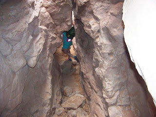 |
| Climbing Through a Crevice |
The Ranger demonstrated how to proceed through each obstacle and the group would follow suit. Some of the highlights of the trek were that they went through a walkthrough arch
 |
| Walk through Arch |
a crawl through arch
 |
| Crawl Through Arch |
slid down a rock to a crevice
and did a two foot leap over a five foot deep drop to another rock.
They saw a Skull Arch and the Kissing Turtle Arch which were very unusual formations.
 |
| Skull Arch |
 |
| Kissing Turtles |
The Ranger stopped about every twenty minutes to explain the various plant and animal habitats and did a great job. It was a challenging hike and those more able, such as Tim, had to help others through the course. It was a three quarter mile loop which took three hours and was well worth the journey.


Sounds like a wicked hike.. good for you, Tim. I would have opted out with Kate!
ReplyDelete