Wednesday, June 27, 2012

TETONS PART IV


June 25th, Monday

Our plan was to be in Jackson early so that we could call a dentist, get an appointment and get my cap put back on. When we left at 7:15am, there was little traffic until all of a sudden there were two ranger cars and all kinds of cars stopped on the side of the road near Oxbow Bend. They were letting a Mama Grizzly and three cubs cross the road. We took some pictures through the front windshield right into the sun, so they really didn’t come out that well. But, we were thrilled to see them up so close again. Those claws are amazing!

Mama Grizzly
One of the Cubs

We continued our trek to Jackson and at 8am I called a dentist, Dr. Owens, and, since she had a no-show, she took me right in. She was very professional and efficient and my cap is now back in place.

We did a few errands while we were in town and headed back to the RV. As we passed the road to the Bridger-Teton National Forest, we saw a gathering of cars down that road parked on both sides. Knowing that this occurrence generally meant some kind of wildlife sighting, we took the detour, grabbed our cameras and headed off through the woods. There were two moose across the river eating the bushes. One was very obvious, but the other stayed pretty well hidden.
Moose Eating Bush
So, I guess you can say we have now seen wildlife in the Tetons!

June 26th, Tuesday


Since we enjoyed our trip down the Snake River so much, we ventured out once again. This time, it took Tim a little longer to make the bike ride from the take out at Pacific Creek back to the headwater at the dam because the winds were so high against him. He made it back, however, and off we went. The wind was at our back and even though they had decreased the output of water at the dam by 200 gallons per second, we had a good ride without paddling much at all.
Floating Down the Snake River

Steering But Not Paddling Much!

Half way down the river, a bald eagle dove right in front of the canoe and clutched a fish out of the water. He returned to the bank, held the fish down with his talons and started tearing at it. We paddled right up to the shore and were surprised that he didn’t take off with is catch. Instead, he pretty much ignored us and ate his lunch.
Bald Eagle Eating Fish
Keeping Watch
Who Are You?
I have only gotten two other pictures of a bald eagle before and one of them was at a rapture farm where the bird was in captivity. The other flew overhead and I had to use the full zoom to get any picture at all. This time, I just sat and clicked away not more than ten feet from him for about ten minutes. When he decided to move, he only flew another fifteen feet up the hill, so I was still able to get a few more good shots. What a thrill! What a great day on the water!

And the moose was right where we left him yesterday so we got a few more shots on the way home.

We have had a wonderful time here in the Tetons-enjoying the warmer weather, hiking, canoeing, campfires and especially seeing the wildlife these past few days. The Teton Mountain Range offers spectacular views of snow covered peaks and is a virtual playground for those that love being outdoors.

Monday, June 25, 2012

TETONS PART III


Sunday, June 24th

We were determined to start this day off earlier than yesterday while it was still a little cooler as the day promised to be quite hot in the afternoon. Can you believe we have gone from being so cold to now worrying about being hot?

We were up and out on our way to Jenny Lake by 8:15am and arrived there in time to get a 9 o’clock boat shuttle over to Teewinot Mountain. Teewinot is the indian spelling of Teton. The boat shuttle was a quick 15 minute ride across the lake to the mouth of Cascade Canyon.

Trail to Hidden Falls
The trail head for Hidden Falls started immediately upon disembarking from the shuttle. We put on our backpacks, grabbed our hiking sticks and we were off. The climb to Hidden Falls is a “Moderate” hike climbing 150 feet in .6 miles climbing over rocks, tree trunks, and fallen branches.
Before we reached the Falls, we could hear them and see the cascades below the Falls. The Falls were magnificent-another Mother Nature wonder!
Cascades from Falls
Hidden Falls
We continued on the trail to Inspiration Point. This trail is given a “Moderate-Strenuous” rating. We climbed another 270 feet in elevation over another .5 miles.
Halfway up there is a point called Contemplation Plateau
Contemplation Plateau

where most folks rest and contemplate if they want to continue! We did and were glad of it.
Trail to Inspiration Point
Kate Hiking Up the Inspiration Point Trail

Tim Hiking Up the Inspiration Point Trail

 While the climb was steep and difficult, the views of Jenny Lake and the Teton Range were incredible.

We stopped for a breather and then continued for about another mile and one half up into the Cascade Canyon Trail hoping to see wildlife (yes we had our bear spray with us!) Apparently, we turned around too soon as another hiker on the way down said he had seen moose just a short way farther than we had gone.

Our total hike was about 550 feet in elevation just over two miles. Pretty steep! Our total miles were 4.3 with a total time of 3 hours with many stops thrown in for resting and picture taking. I believe our legs are getting stronger as we tackle more difficult climbs.

We had quite an invigorating morning and planned to relax some at String Lake for the afternoon. We drove over there and launched our canoe. The lake is crystal clear, cool and inviting.
String Lake
Fun on the Water at String Lake

 We canoed almost the length of the lake, beached the canoe and had lunch. Tim went off to catch some of those fish we saw yesterday while I sat, relaxed, read and actually cooled off in the icy cold waters every once in a while. Alas! No fish for dinner. As it turned out, they were nonedible fish called “suckers.” Tim hooked several of them but they were so powerful, they snapped the line. Just as well if we couldn’t eat them. An interesting fellow from Germany stopped to chat with Tim. He had a submersible movie camera which he tied to a stick and attempted several times to film the school of fish under the foot bridge. All to no avail, but Tim had fun watching the shenanigans he went through to try to get the shot.

After a final refreshing cold dip in the lake, we paddled back to the take out area, loaded up the canoe and headed home. Another long but wonderful day to add to our memory banks.
Tim and Kate at Hidden Falls


TETONS PART II


Saturday, June 23rd

Saturday morning presented itself as a bright and sunny day with beautiful blue skies and billowy white clouds. Perfect for our hike around the String and Leigh Lake area.

Jackson Lake is the northernmost lake in the Grand Teton National Park. Then, the next to the south is Leigh Lake which connects on its southern shore to String Lake. Further south still lies Jenny Lake.

There is much activity around all of these lakes, not the least of which is hiking.  Each lake has hikes designated as “Easy” to “Strenuous” and we were looking to do the “Easy” one to Leigh Lake and back as a round trip of 1.8 miles.

The day started out on a bit of a sour note as I lost a crown off of one of my teeth while flossing. Not to worry, though, because I found the crown and put it safely away until we can get down to Jackson on Monday and find a dentist!

We didn’t arrive at the lake until almost noon time as we stopped at the Jackson Lodge on the way to access their wifi to post our last blog, which we will be doing later for this one as well.

We hadn’t been to String Lake before and we were very surprised to see so many people in swimming, tubing, paddle boarding, kayaking, and canoeing. As we walked around the east side of the lake we found folks who had beached their canoes and were having lunch on shore and just really enjoying the warm weather.
String Lake

 We came to the spot where you would need to portage any boat from String Lake to Leigh Lake and walked over to Leigh Lake to investigate the distance and the put in area for the canoe there. We originally thought we might try doing that another day, but realized the portage was a little too long for us to do. It would mean that we would have to carry the canoe about 200 yards (length of 2 football fields) from one lake to the other and then back again later in the same day. We quickly nixed that idea! But, we did decide to extend our hike today to do the entire String Lake Loop Trail.
Leigh Lake Portage Stairs for Canoe or Kayak

Further on the walk we crossed the bridge over the upper part of String Lake where we saw huge fish hanging out around the rocks just waiting to be caught. Oh, to have had that fishing pole with us!

The hike, as I said, was labeled as an easy walk, but we did hike up about 400 feet on some pretty narrow and steep areas. The trail wound through the forest beneath Rockchuck Peak and Mount Saint John.

Hiking the Trail beneath the Peaks

We took our time and really enjoyed the views of the lake and the mountains all around us.
String Lake

At one point, a young man came hustling past us with his snowboard strapped to his backpack. He told us that he had just climbed up to one of the peaks and did some snowboarding. Can you believe that! End of June with mid 80s temperatures with him in shorts and a sleeveless T-shirt. He fairly ran down the trail ahead of us off to another of his adventures, I imagine.

He wasn’t the only young person who passed us by. There were at least four other young men who evidently were running the trail as an exercise. We got enough exercise just hiking it, thank you very much.

We had started hiking the trail at one end of String Lake and it ended at the opposite end. So the advertised 3.7 miles turned out to be 4.3 miles to get back to the parking lot where we had left our car. It was the perfect length, actually, to fill up a full afternoon. It took us a total of two and one half hours to complete the route.

On the way home, we stopped at The Chapel of the Sacred Heart on Signal Mountain for the 5 o’clock Mass. It was packed. This is a chapel that had been built in the 1920s, and rebuilt twice the latest time being in 2003, I believe, with a donation in memory of one of the World Trade Center victims who had lived in Jackson Hole. It’s a log cabin type of structure and is quite charming as was the priest who told us it had all the amenities of a city church including a choir.. and we were it.

    
Chapel of the Sacred Heart

Saturday, June 23, 2012

TETONS PART I


June 19th through June 22nd.   
We arrived in the Tetons from Yellowstone on Tuesday the 19th. It was an easy 2 hour ride down into the Park. Since then, we have been doing quite a bit. On the 20th, we took a driving tour of the Tetons all the way down to Jackson (Hole) by way of Teton Village. The scenic route to the Village is one we won’t take again. It is unpaved in spots and lots of frost heaves. The views, however, were fantastic.  Especially the ones from the top of Signal Mountain overlooking the Potholes (small ponds) and valley on one side and Jackson Lake and the Teton Range on the other.
View from Signal Mountain to Jackson Lake and Teton Range
View from Signal Mountain of Potholes and Valley

 We stopped at quite a few overlooks and, of course, Jenny Lake which is magnificent.
View from our lunch spot on Jenny Lake
Jackson Hole is actually the name of the whole valley between the Teton Mountain Range, but many people call the town of Jackson, Jackson Hole. As you drive through the valley, you can see why they called it the “Hole.” There are mountains as far as you can see on the east and west of the cavernous valley. While the elevation is 6700 to 7200 in most areas of the Park, the peaks of the Teton Range loom over us as high as from 10,000 feet all the way up to the Grand Teton at 13,770 feet. The snow covered mountains that sit directly next to the lakes, look so close that you feel you can reach out and touch them. 

On the main thoroughfare, there are many meadows and warnings for wildlife crossing the road, but to date we have not seen any. A little disappointing after all that we saw in Yellowstone. We do see quite a lot of bicyclists with their bikes bogged down with all of their camping gear. Each of the National Parks reserves so many spots at each campground for hikers and bicyclists so that they are always able to find a place to rest. It is amazing they can make the climb up these hills with all that gear.

The main route through the Park is named after John D. Rockefeller, who, after visiting Jackson Hole in 1926, was upset that there was “haphazard development” going on in the area. He began buying up the land and eventually donated 32,000 acres to the Federal Government for the Teton National Park. Thank you Mr. Rockefeller! The area became a National Park in 1929 with earlier protection from the federal government as The Teton Forest Reserve in 1897.

The earlier inhabitants of the Tetons were the Paleo-Indians about 10,000 years ago and then, in more modern times, the Shoshone, Crow, Gros Ventre and Blackfeet frequented the area in the summertime following the animal trails across the Continental Divide. From the 1820s to the 1840s the fur traders would meet and exchange their wares in designated valleys.

As if the wonderful vistas are not enough, the lovely warm weather has arrived! It has been mid-70s to 80s for a couple of days and we have put aside our polar fleece jackets, warm hats, and gloves for layers of short sleeve shirts under long sleeve shirts and zip off hiking pants that turn to shorts. The mornings are cool, noon time is hot and evening is cool again. But so much better weather than we have had thus far in this area.  We aren’t even using the heater in the RV anymore!
Thursday, the 21st, we canoed on Jackson Lake which is quite large. Our campground is about a quarter mile from the lake, the village and the marina. There is a boat launching area there which makes it really convenient.
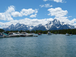
Jackson Lake Marina

The weather was perfect with very little breeze and the lake was like glass. We canoed for over 4 miles all around one area of the lake. The lake is huge and we could never canoe the whole thing. We lunched on an island and took in the scenery before heading back in.
Canoeing on Jackson Lake


On our road trip the other day, we explored where to put in the canoe and the take outs for the Snake River. We decided upon putting in at the dam from Jackson Lake and to take it out at the Pacific Creek Landing/Cattleman’s Bridge.  We arrived at the dam today about 10am and unloaded everything for the paddle down the river.
Jackson Lake Dam


 I waited with the canoe while Tim drove the car to the takeout spot 5 miles downriver. He rode his bike back, uphill all the way, and we headed out at about 11:30.
Tim Riding Back from Pacific Creek Landing

The current was swift and we didn’t have to paddle much at all until we rounded the Oxbow Bend. Then the wind hit us straight on and we had to paddle quite a bit to make any headway. We were warned that just before the takeout the Pacific Creek merged with the Snake and the current would be very swift to cross to make the landing before going down into a white water area. We reached the takeout sooner than we thought we would and had no trouble navigating the currents. This is a favorite take out spot for many kayaks, canoes and rubber rafts, while many white water rafters continue down the snake to rougher waters and bigger rapids. We were happy with floating down the top half of the river and think we may do it one more time before we leave the Tetons.
We only did the first part...our canoe in background.
Cruising Down the Snake River!

Tuesday, June 19, 2012

YELLOWSTONE FINALE

June 19th

We’ve seen so much! From North to South and East to West encompassing the entire Grand Loop. We’ve seen geysers, hot springs, fumaroles, mud volcanos, lakes, streams, rivers, mountains, falls, and canyons. We’ve walked, hiked, and driven through the most incredible landscapes and seen gorgeous vistas. We’ve seen grizzly bear, black bear, elk, moose, bison, marmots, coyote, wolf, mountain goats, long horned sheep and pronged horned deer.

We were once asked why we would stay in Yellowstone for 2 full weeks. While we have seen a lot, there are still trails, lakes, and mountains we did not explore. You could spend a lot more than two weeks here and still not see it all.

Our last few days have been spent at a leisurely pace with Tim fishing for a morning and our returning to the Firehole area to view the Artist’s Paint Pots and the Fountain Paint Pot.
Fouintain Paint Pots

In fact, on our way back from there today, the Bison helped us celebrate our last day! They led a parade right down the Grand Loop road for 10 miles. We were 10 cars back from them and the Ranger cars that eventually came to prod them along. It was really like a modern day cattle drive.

It took us almost one and a half hours to go 10 miles. Some of them lagged behind and kept going in between the cars. At one point they came so close to the car, that I could have reached out and touched them from the passenger seat.  Scared the heck out of me when I had focused my camera on one by the side of the road and another one came right up to the window!
Lagging Behind the Herd

Up Close and Personal with NO Zoom!
We’ve enjoyed our time in Yellowstone despite the cold. And now we are off to the Teton National Park where we are looking forward to many more adventures. The Tetons are just outside the southern entrance to Yellowstone and not more than a two hour drive from here. Colter Bay here we come!

Sunday, June 17, 2012

YELLOWSTONE PART IX


Saturday, June 16th:

 Tim took his early morning ride and found Elk and Bison on the side of the road.


Montana or bust! Off we went on a gorgeous 70 degree day up the Northwest section of the Grand Loop Road. Our destination was originally Mammoth Springs to see the travertine terraces, but since Montana was only 5 miles north of that, we decided to take the plunge and drive into Gardiner which is just outside the North Entrance to the Park.  We drove past many interesting things along the way and promised ourselves we would stop at them all on the way back.

When we arrived in Gardiner, there were folks on horseback parading down the street with flags waving. Evidently, there is a rodeo in town tonight. Sorry we won’t be there to see it. Gardiner is a quiet little town with all kinds of storefronts for the usual gifts and knick knacks along with many white water rafting companies and corrals for horseback rides. While interesting choices, we opted to find the fishing store where Tim bought wading boots so he could venture into the streams. Maybe that would help with his fishing!?!

We returned to the Park through the Arch that was dedicated to Teddy Roosevelt as he use to frequent the Park. The sign above it says,   “ For the Benefit and Enjoyment of All.”
Tim Driving Through the Roosevelt Arch

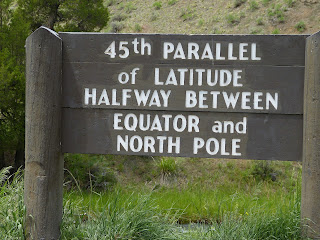
We also crossed the 45th Parallel!

Mammoth Springs was our next stop. Here we saw incredible sights. It almost felt like we were back in Carlsbad Caverns. The literature tells us that the Terraces are formed the same way the stalagmites and stalactites were formed with the combining of carbon dioxide in hot water forming a weak solution of with carbonic acid. This in turn dissolves the limestone formations under the Earth’s surface and it seeps downslope. Once the solution reaches the open air, the carbon dioxide it escapes and forms carbon carbonate and creates a material called travertine.  Some of the travertine, we are told, builds up at a rate of 3 feet per year.  The shades of the terraces are colorful when they are active, but when inactive the color turns to white or dull grey.

We toured the Lower Terraces by foot climbing steep stairs (244) plus many  ramps between the sets of stairs.  The Upper Terraces were easily viewed by driving through the designated one way road.  Surprisingly, we found some wildflowers near one of the terraces.
Stairs at Lower Terraces

Lower Terraces
Upper Terraces

Upper Terraces


Wildflowers on Upper Terrace

Shortly after the Terraces, we came upon a grouping of rocks called the Hoodoos..not sure why. These are actually “pieces of old hot spring terraces that tumbled down the mountain in massive landslides.” They are quite intimidating as you drive among through the side road. They look like they aren’t quite through toppling over!

Hoodoo Rocks

We stopped to see Sheepeater Cliff which was named for the Shoshone tribe who used to dwell here. The Native Americans often used obsidian from the Obsidian Cliff nearby for making points and tools.

Roaring Mountain loomed on the east side of the highway. It looks very bleak now, but the noise from all of its fumaroles used to scare the folks on the wagon trail. It’s pretty lifeless now, but we did see one or two of these vents still active. 

There were several lakes, rivers and streams along the way. The mountains and meadows never cease to amaze us. 

We passed through an area called the Golden Gate because of the gold color on the cliff wall. From the same spot we spied the Rustic Falls.
Golden Gate

Rustic Falls

Back at the RV, we relaxed by the campfire and enjoyed the pleasant weather of the day.